
Guide · Map layers
Map layers
Turn on trails, terrain, land, water and weather over any map, and read the legend.
- Tracking options
- Map layers
Layers are extra information drawn over the map: who may drive a forest road, how steep a slope is, whose land you're on, where it's raining. They're all off until you turn them on, and you can combine as many as you like.
Tap Tracking options on the map screen.
Tap Map layers (it says how many are on, such as 2 on).
Flip the switch beside any layer. Tap ‹ Tracking to go back; the map shows it at once.
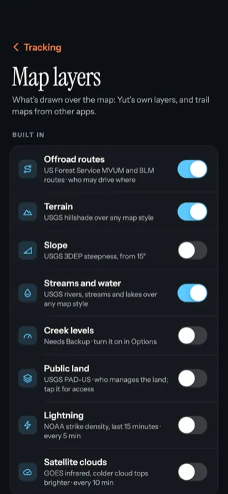
- ‹ Tracking goes back to the settings.
- A switch for each layer. Blue is on.
- Some layers need Backup or only work in the US. The line under each name says so.
What each layer shows
| Layer | Shows | Learn more |
|---|---|---|
| Offroad routes | Who may drive which Forest Service and BLM road | Offroad routes |
| Terrain | Shaded hills and valleys | Terrain, land and water |
| Slope | Steep ground, 15° and up | Terrain, land and water |
| Streams and water | Rivers, streams and lakes | Terrain, land and water |
| Creek levels | Stream gauges, rising or falling | Terrain, land and water |
| Public land | Who manages the land | Terrain, land and water |
| Lightning | Strikes in the last 15 minutes | Weather, lightning and fires |
| Satellite clouds | Cloud cover from space | Weather, lightning and fires |
| Active fires | Fires seen in the last 24 hours | Weather, lightning and fires |
| Imported | Trail maps from your own files | Import trail maps |
The legend
When a layer that uses colours is on, a legend card under the coordinate card explains them: access classes, trail difficulty, slope bands, land managers and map symbols. Turn it off in Tracking options under Map → Legend.
Updated October 12, 2026 · Still stuck? Ask us